
Open City
In war, a city that has abandoned all defensive efforts.
Open City: Lilac Preservation Project, Manhattan
Lilac’s significance as a naval vessel is indeed that she is the only surviving example of a vessel that once served a vital role in the navigable waters of every coastline of this country. She is unique in that she is the last unaltered steam propelled and steam hoisting lighthouse tender designed for work on the open sea and connecting bays and sounds. She is also the last such vessel to survive that was operated by the United States Lighthouse Service, the civilian manned agency responsible for maintaining aids to navigation from 1910 to 1939, when this work was assumed by the United States Coast Guard.
For more information visit: http://www.steamerlilac.org/
Open City: Castle Clinton, Manhattan
Located at the southern tip of Manhattan Island, Castle Clinton represents not only the growth of New York City, the the growth of a Nation. First intended to keep out a British invasion in 1812, the Castle has transformed over the years to welcome theater goers, immigrants, sightseers and now millions of visitors to New York Harbor.
For more information: http://www.nps.gov/cacl
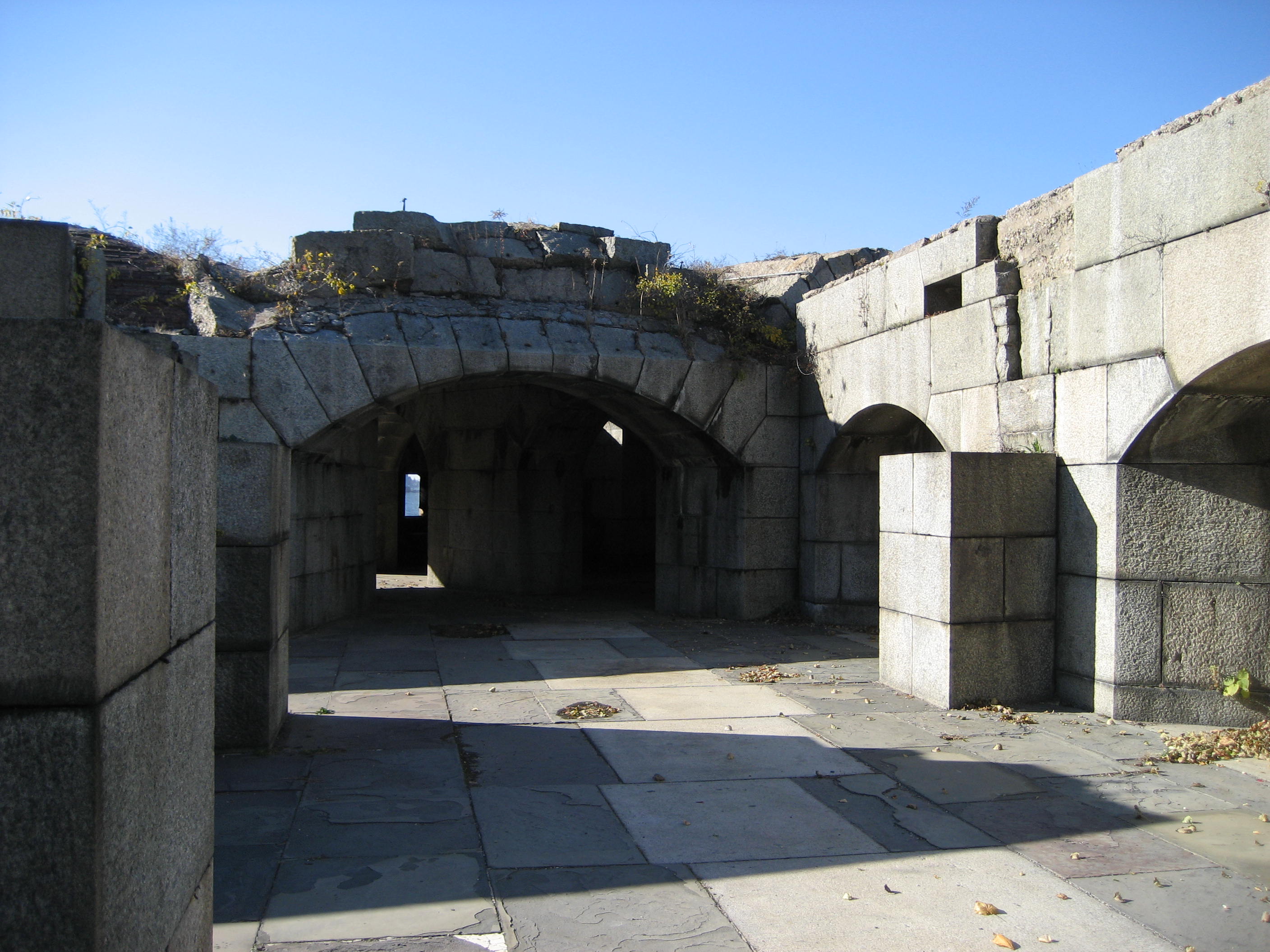
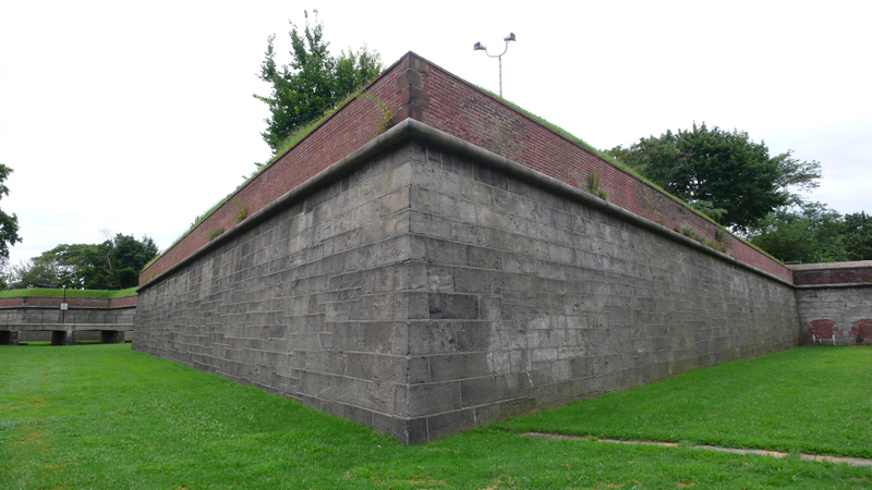
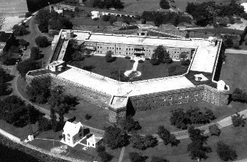
Open City: Governors Island, Manhattan
Open City: Fort Totten, Queens
Construction began on Fort Totten in 1862 after the land was purchased by the U.S. Government in 1857 from the Willets family. The fort sits on Willets Point, near Bayside in Queens County, New York. The original purpose was to protect the East River approach to New York Harbor, along with Fort Schuyler, which faces it from Throgs Neck on the opposite side of the river entrance. The fort was named in 1898 after Joseph Gilbert Totten.
In 1954, the fort became a Project Nike air defense site. Although no missiles were located at Fort Totten, it was the regional headquarters for the New York area; administrative offices and personnel housing was located at the fort. Fort Totten was also the headquarters for the 66th Anti-Aircraft Missile Battalion, Battery D, whose missiles where located at nearby Fort Slocum on Hart Island. This use of Fort Totten was discontinued in 1974.
Much of the fort has become a public park and is open to the people of NYC for tours by the New York City Department of Parks & Recreation. During the winter months, a large variety of migratory waterfowl can be observed in the surrounding Long Island Sound and Little Neck Bay. Most of the buildings are now run-down and not used. Fort Totten is also a sports complex, as it holds baseball fields and three soccer fields used for youth soccer.
A Walk Back in Time
Date: Saturday, Aug 04, 2007 | 2:00 p.m. – 3:30 p.m.
Come tour the catacombs of Fort Totten, built during the War of 1812 to protect New York’s Harbor
Location: Fort Totten Ranger Station, Fort Totten Park
Read full Wikipedia article >>
- “Fort Totten, New York.” Wikipedia, The Free Encyclopedia. 17 Mar 2007, 19:33 UTC. Wikimedia Foundation, Inc. 25 Jul 2007.
Open City: Fort Schuyler, The Bronx
Fort Schuyler is a preserved 19th century fortification in the New York City borough of The Bronx, that houses a museum, and the Marine Transportation Department and Administrative offices of the State University of New York Maritime College. It is considered one of the finest examples of French-style fortifications. The fort was named in honor of Major General Philip Schuyler of the Continental Army. It is listed on the National Register of Historic Places.
Fort Schuyler was one of many forts built along the east coast of the United States in the aftermath of the War of 1812 when it became brutally apparent that the US coast was poorly defended against foreign invasion. Fort Schuyler was dedicated in 1856 after only 75% completion, and was strategically positioned to protect New York City from naval attack through Long Island Sound; guarding the eastern entrance to New York Harbor. It is located at Throgs Neck in the southwest portion of the Bronx at a point where the East River meets Long Island Sound. Fort Totten faces it on the other side of the river. Their naval batteries created a bottle-neck of defenses against ships attempting to approach New York City. Fort Schuyler, at its peak, boasted 440 guns. Later, it would be fitted with various other pieces throughout the ever-modernization of coastal defense artillery, once including 10″ and 12″ naval guns on disappearing carriages installed on the roof and on the peninsula around the fort. Coastal artillery emplacements at the fort lasted until 1935.
Read full Wikipedia article >>
Visit the Maritime Industry Museum web site >>
- “Fort Schuyler, Bronx.” Wikipedia, The Free Encyclopedia. 4 Jul 2007, 21:18 UTC. Wikimedia Foundation, Inc. 25 Jul 2007.
- Image courtesy of The State University of New York Maritime College, Stephen B. Luce Library. http://www.sunymaritime.edu.
Governors Island, Manhattan
At the confluence of the Hudson and East Rivers, in New York Harbor, sits Governors Island. A mystery to most New Yorkers, the Island served as the longest continuously active military post in the United States, from 1794 until 1997.
- Governor’s Island by Christina Wilkinson. http://www.forgotten-ny.com.
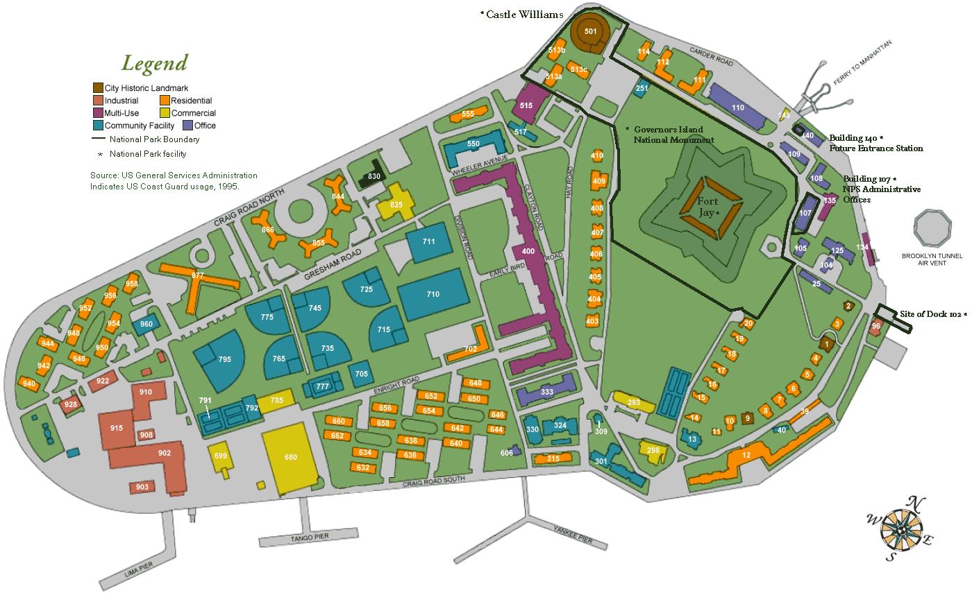
- w:Governors Island U.S. General Services Administration map; indicates U.S. Coast Guard usage, 1995.
Open City: Fort Totten, Queens
BY
|
Posted on | FILED UNDER
Categories Information, Open City, Queens
Fort Totten is the official headquarters of the U.S. Army Reserve’s U.S. 77th Division, the “Statue of Liberty Division”.
Construction began on Fort Totten in 1862 after the land was purchased by the U.S. Government in 1857 from the Willets family. The fort sits on Willets Point, near Bayside in Queens County, New York. The original purpose was to protect the East River approach to New York Harbor, along with Fort Schuyler, which faces it from Throgs Neck on the opposite side of the river entrance. The fort was named in 1898 after Joseph Gilbert Totten.
In 1954, the fort became a Project Nike air defense site. Although no missiles were located at Fort Totten, it was the regional headquarters for the New York area; administrative offices and personnel housing was located at the fort. Fort Totten was also the headquarters for the 66th Anti-Aircraft Missile Battalion, Battery D, whose missiles where located at nearby Fort Slocum on Hart Island. This use of Fort Totten was discontinued in 1974.
Much of the fort has become a public park and is open to the people of NYC for tours by the New York City Department of Parks & Recreation. During the winter months, a large variety of migratory waterfowl can be observed in the surrounding Long Island Sound and Little Neck Bay. Most of the buildings are now run-down and not used. Fort Totten is also a sports complex, as it holds baseball fields and three soccer fields used for youth soccer.
Open City: Fort Tryon Park, Manhattan
BY
|
Posted on | FILED UNDER
Categories Culminant, Information, Manhattan, Open City
“Originally inhabited by the Weckquaesgeek Tribe, who lived in the area until the early 17th century, this densely forested high ground at the northern end of Manhattan was Lang Bergh or Long Hill to the early Dutch colonists. The Continental Army called the strategic series of posts along the Hudson River Fort Washingtonâ€? during the summer of 1776, until Hessian mercenaries fighting for the British forced the troops to retreat. The British then renamed the area for Sir William Tryon (1729-1788), Major General and the last British governor of colonial New York.”
“Containing one of the highest points in Manhattan, Fort Tryon Park towers above the Hudson River, offering magnificent views of the Palisades and the lower Hudson Valley that challenge the notion that Manhattan’s best vistas are experienced from its skyscrapers.”
– from the NYC Department of Parks and Recreation website >>
Open City: Definition
BY
|
Posted on | FILED UNDER
Categories Definition, Open City
Open city (n.): a city that is declared demilitarized during a war, thus gaining immunity from attack under international law.
Read Wikipedia article: http://en.wikipedia.org/wiki/Open_city
Information on Roberto Rossellini’s Roma, Città Aperta (1945): http://en.wikipedia.org/wiki/Rome%2C_Open_City